News
Tropical Storm Erin forms in eastern Atlantic

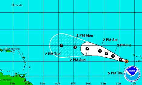
MIAMI, USA — Tropical Storm Erin formed in the eastern Atlantic on Thursday morning as the system moved away from the Cape Verde Islands.
According to the National Hurricane Center in Miami, at 5:00 pm EDT on Thursday, the centre of Erin was located about 245 miles west-southwest of the Cape Verde Islands, moving towards the west-northwest near 15 mph. This general motion is expected to continue for the next couple of days, with a decrease in forward speed.
Maximum sustained winds are near 40 mph, with higher gusts. Some strengthening is forecast during the next 48 hours.
Tropical storm force winds extend outward up to 35 miles from the centre.
Meanwhile, a broad area of low pressure, accompanied by a large but disorganized area of cloudiness and showers, moved over the Yucatan peninsula on Thursday morning. Development of this system is not anticipated while it moves over land but there is still potential for development once the disturbance moves over the Gulf of Mexico on Friday.
The low is forecast to move toward the central Gulf of Mexico where the upper-level winds would only favour slow development, if any. This system has a medium chance — 50 percent — of becoming a tropical cyclone during the next 48 hours, and a high chance — 60 percent — of becoming a tropical cyclone during the next five days.


